Showing posts with label World. Show all posts

Monday, August 8, 2016

Two New Pay What You Want products on RPGNow

I took two of my free products and put it into PDF form. They have more minimal advertisement, are portable, and very flexible.

Now available on RPGNow as Pay-what-you-want

ABS12 Flexible Solo Game Engine v 1.0


ABS12 Flexible Solo Game Engine v1.0

This is a flexible solo game engine that is meant to take the place of a Gamemaster (GM) for answering questions or finding the results of modified rolls. A chart with results for 1D6, 1d8, Fate, Fudge, 1D10, 1D12, 2D6, 3D6, 1D20, 4D6 JAGS, and 1D100 systems is included. It makes it a versatile game engine.

Suggested Price $0.99
Pay-What-You-Want


Aioskoru World Guide v 1.3


Aioskoru World Guide

This is my collection of some basic information for the world of Aioskoru. Aioskoru is an Open Gaming License OGL world. I use this world in my ABS12 Solo Gaming stories and map technique book and posts.

Included in the book are some names of regions as well as some naming vocabulary. Also suggested measurements for direction, time, distance, and weight are given. A collection of biome and animal locations is suggested. About 60+ universal or popular creatures are suggested with references to RM and HARP page numbers and D20 SRD and PFSRD websites.

Suggested Price $1
Pay-What-You-Want


Any donations would be appreaciated.

Tuesday, May 31, 2016

Quick free world maps using GIMP filters and Donjon fractal maps - Preview of Ebook

Quick free world maps using GIMP filters and Donjon fractal maps series:
Part 1: Getting a fractal map,
Part 2: Getting different types of maps,
Part 3: More accurate 3D maps with mountains,
Part 4: Zooming and resolution,
Part 5 Expanding the Zoom Limits.
Part 6: Quick outline maps

[Click on the blog page links above if you want to see the free instructional content I've given out on my blog. This book will include that and new instructions not shown in that content, which do the results below]

I just wanted to update the progress to make an ebook showing the steps to do the ultra zoom elevation maps. I'm still trying to finish up the outline method instruction that I wanted to include.

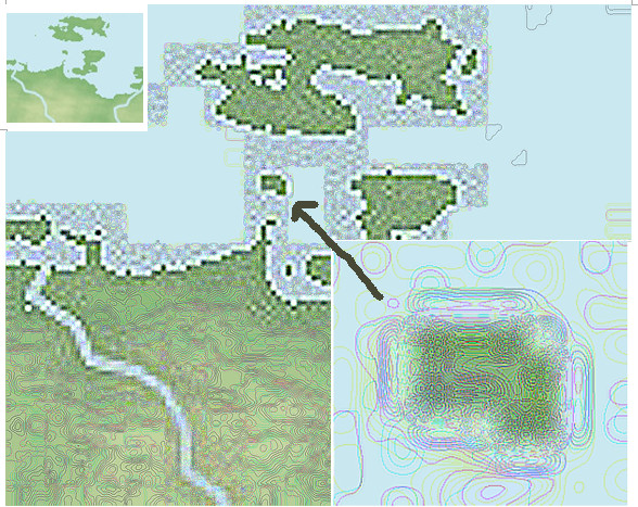
Here is new content I created to show the step by step, this time looking a tiny island.


In the left upper corner is the original. The middle shows the topographical line version. The lower right shows the tiny island. Compare the lower right to the original in the upper left. I believe it is a phenomenal results. I'm very pleased.

I don't have an ETA on when it will be finished.

Hopefully I can keep the price low. It will depend on the size of the file, since that's how they calculate ebook charges. With all the maps, it drives up the price up the most, more than the text itself. Text is very cheap for ebooks. But I'm trying to keep the images to a minimum when possible.

It will have all of the content in posts 1 to 6 as well put into one ebook as well as the new ultra zoom and outline methods only shown but not revealed in my free posts.

Available from Google Play Books.
https://play.google.com/store/books/details/Ken_N_Wickham_Quick_free_world_maps_using_GIMP_fil?id=tvZmDAAAQBAJ

Also available on Kindle and RPGNow
https://www.amazon.com/Quick-world-filters-Donjon-fractal-ebook/dp/B01H131XPY/

http://www.rpgnow.com/product/187006/Quick-free-world-maps-using-GIMP-filters-and-Donjon-fractal-maps

Wednesday, May 11, 2016

Story v RPG Part 4: Potential Pitfalls of using a RPG session for a Story.

Story vs RPG Series
Story: Elements
Story vs RPG Part 3: Character Information
Story v RPG Part 5: Personality Types
Story v RPG Part 6: Alignment, Morality, and Ethics
Story vs RPG Part 7: Character Needs
Story vs RPG Part 8: Character emotions
Story vs RPG Part 9: Lies - Our characters darkest secrets
Story vs RPG Part 10: Setting - cultures
Story vs RPG Part 11: Pair Dynamics
Story and Game Structure: Storylines
Story vs RPG Part 12: Larger groups - conformity & deviance

If you like this series support it by buying it today for kindle all in one file and without advertisement. Available in most countries that Amazon supports. 

The character personality post isn't finished so I will post this other post that I've been working on for the time being. It shows the three main pitfalls of using a RPG session for a story. My plans were to add more, but if I think up of more I will do a second potential pitfalls continuing the numbering.

Potential Pitfalls of using a RPG session for a story


Great! Your going to use your greatest role-playing game (RPG) story for a novel or story. A number of issues may arise based on that decision. Issues that might have to be considered carefully. You may have to consider the ownership of the world and the characters. You may also have to take your heroic characters and treat them rougher, trust the other character cast less, and test them much more than in the game.

1. Use a World or World Building
First of all, unless you've created your own world by doing some world building or the world is public domain such as Wonderland, Oz, Arthurian Kingdom, Pride and Prejudice, Dracula, or such. Even then, if what you use in the game is someone else interpretation the world, and you decide to use their creation as the basis for your game and story world, then they may have added their own content on to that original content, which may seep into your story.

So using a original built world as the basis for a story is ideal and avoids possible infringement. You may even use the public domain material in your own adopted world, alter, and add more material to that based-on content. Use the original source to modify and make your own version of the world, rather than using a published game source.

2. So who is going to play the main characters in a RPG?
When playing with a group of friends or acquaintances, the other characters are normally controlled by other people. They have rights and ownership to that character's behavior and choices. So if you take what they do, say, and have created, then they are part owner in the story.

You may have to only use the character that you have created, rather than pulling out the legal papers to sign over their character rights - which isn't very beneficial to the gaming sense of fun and friendship.

An author, unless collaborating, create and control their own characters. They have to be able to jump into the minds of their characters throughout the scene. In a sense, mild forced split-personality is helpful.

Therefore take your character(s) and put them in their own story you create.

3. One of the biggest difference is conflict.
Conflict, loss, and failure in stories makes great tension. You want your written characters to struggle, hit obstacles, and experience the pains, setbacks, and emotions of despair and disasters. When things are looking up, a car hits them from the side or their best friend stabs them in the back.

In gaming, that type of game master (GM) or dungeon master (DM) - the person leading the game story - their intrusion, making characters fail, might make it feel like sabotage and that they are against your group of players. In RPGs victories are more important. In gaming you don't want players to die unless they do something wrong in the final battle. So gaming characters aren't normally used in the same way that a story uses the characters.

Own World + Characters you Own + Interesting Conflict


With these first three issues to consider and taken care of, your on your way to avoiding potential pitfalls to using a game session as the basis of a story.

Hopefully I will get further on the character personality type post. I'm not sure if I can finish it yet. I'll post some other small piece maybe if not.

ABS12 system

Thursday, April 21, 2016

Quick free world maps using GIMP filters and Donjon fractal maps - Part 6: Quick outline maps

Quick free world maps using GIMP filters and Donjon fractal maps series:
Part 1: Getting a fractal map,
Part 2: Getting different types of maps,
Part 3: More accurate 3D maps with mountains,
Part 4: Zooming and resolution,
Part 5 Expanding the Zoom Limits.

Outline maps are good to have for several reasons.

GMs can use these maps to label the different areas and regions of the world. Since they lack features on the land, it gives you plenty of room to add boundaries for kingdoms and such.

This is also a great method to show changes in populations and kingdoms over time.

You can give these mostly featureless maps to players to help them keep track of where they are, yet not reveal too many details

Two main quick outline methods

Two main quick outline methods exist in the toolset to make outline maps of the entire world. They are the Landmask and the Antique map methods. The Landmask blackens out the large lakes and ocean waters. The antique changes the background and makes the waters look slightly shaded for a dimensional depth effect.

Landmask method


  1. Go to http://donjon.bin.sh/world/.
  2. Enter your recorded Seed Number from part 1 into the Random Seed Field to bring up your map. Also change the Iteration to 25000. Verify that this is the correct map. You may have to adjust the Ice and Water.
  3. Make sure your Ice and Water percentages are the same as your original map. Also check the rotation, if you prefer a different perspective of the world.
  4. Adjust the Image Height to the height size in pixels that you want. The default is 400. You can increase it up to 2000 pixels high.
  5. To make a Landmask, change the Map Palette to from Atlas to Landmask.
  6. Optionally, you can make any of the types of maps that you did in part 2 by changing the Map Projection, including polar regions and the other types of maps as well.
Save the image to your folder. It will save as a GIF file. Open it with a programs such as Paint and save as a JPG file type if you want to edit and use the file to create labels and boundaries using GIMP.

Antique Map Method

Do the same steps as Landmark Method except:
5. To make a Antique Map, change the Map Palette from Atlas (or Landmark if you did the step above) to Antique Map.

Use either method with the other map types

You can use the two Outline type maps for any of those Part 2 maps.

Here is the poles using Antique Method.


I am saving a third method for a future book, along with a few other advanced techniques. This the results of that method which has no water unlike the prior two methods.


Monday, March 21, 2016

Quick free world maps using GIMP filters and Donjon fractal maps - Part 5: Expanding the Zoom limits

Quick free world maps using GIMP filters and Donjon fractal maps series:
Part 1: Getting a fractal map,
Part 2: Getting different types of maps,
Part 3: More accurate 3D maps with mountains,
Part 4: Zooming and resolution,
Part 5 Expanding the Zoom Limits.
Part 6: Quick outline maps


Available from Google Play Books.
https://play.google.com/store/books/details/Ken_N_Wickham_Quick_free_world_maps_using_GIMP_fil?id=tvZmDAAAQBAJ

Also available on Kindle
https://www.amazon.com/Quick-world-filters-Donjon-fractal-ebook/dp/B01H131XPY/

http://www.rpgnow.com/product/187006/Quick-free-world-maps-using-GIMP-filters-and-Donjon-fractal-maps

Expanding the Zoom Limits

This post continues zooming in closer in the same section as Part 4. It will zoom in even closer. For more information about the region, see part 4.

Chunk of original map

This is the original world map chunk for the zoomed in area. It is 40 pixels height by 40 pixels width. It is approximately two hexes big. In the hex map, you can see that the hexes where it is located show the symbols of mountains. I added the snow mountain symbol.


Hex map. The zoomed area is the snow mountains in the lower right. They are both at the same scale.


Problem with chunk; pixelation

Zoomed in, the information from the original square looks like this. You can actually count the square pixels. Sure you can sort of see valleys and hills in this picture. But I like doing things easy and fast if possible. Yet also maintaining somewhat accurate information. Digging more information from this small chunk quick, easy, and accurate would be nice.


Greyscale 3D map


This is the best view of that area using the newest 3D information that I showed you in post 3. The pixels are very apparent. 


My technique


This sort of was the area that I was focusing on. Later I decided to move it a little more to the right and down more to capture the entire mountain range. You can see the topographical contour lines


A more accurate map with detailed contour lines

Here is that information using my own technique. After finding this technique out accidentally, I recognized the great value in having a quick method to generate a fairly accurate topographical map with contour lines. I also calculated that each line equaled 100 foot elevation change increments. You can see that post here where I count from sea level up to some snow peaks.

I really like this map.


In a prior post and different area near water, I also explored using the contour lines to add smaller rivers. I also tried drawing the hills using the information from the original map. You can see a comparison to old methods and the results of my hand-drawn rivers and lakes in the post here.

Tool to help determine raised and recessed areas

This map helps interpret the contour lines. The light is coming from the northwest corner. Contour line areas with light on the northwest are raised. Areas with dark on the northwest are recessed. I make a few notes concerning different features.


Zooming into the three main peaks


For even closer detail I focus on just the highest peaks, the ones I labelled Twin Peak and Mountain Peak.  I did one for contour and the 3D version. Click on each to see the full image. The original of the next two images is 17 x 9 pixels big. Even then, a lot of information can be extracted from that fragment of the map.

Original Chunk

Original image chunk =>
The little chunk of image above, which is smaller than many words in this sentence, is what was used to create the next two images. This area is less than one hex big. So we are actually looking inside one of the hexes, to gather more information. This information can be used in describing the game world with even more detailed description. It is more like an adventure map were you can place individual buildings, caves, ruins, camps, and sites.

All from the same original fractal map.

Topographical Contour Line map of peaks

For full image, click on the image.

3D version showing raising or recessed elevation

For full image, click on the image

I can see that the peak on the left has two bumps and the one on the right is more pointed, as well as slightly separated from the rest of the slope, sitting more on a shelf. I can imagen that the areas between are great glaciers carving out the valleys and melting into streams and rivers.

Next Month

Next month I will try posting on how to make quick outline maps of the world. Outline maps good for printing off and hand writing in region areas or giving to players. 

Monday, March 14, 2016

Quick free world maps using GIMP filters and Donjon fractal maps - Part 4: Zooming and Resolution

Quick free world maps using GIMP filters and Donjon fractal maps series:
Part 1: Getting a fractal map,
Part 2: Getting different types of maps,
Part 3: More accurate 3D maps with mountains,
Part 4: Zooming and resolution,
Part 5 Expanding the Zoom Limits.
Part 6: Quick outline maps


Available from Google Play Books and RPGNow.
https://play.google.com/store/books/details/Ken_N_Wickham_Quick_free_world_maps_using_GIMP_fil?id=tvZmDAAAQBAJ

Also available on Kindle
https://www.amazon.com/Quick-world-filters-Donjon-fractal-ebook/dp/B01H131XPY/

http://www.rpgnow.com/product/187006/Quick-free-world-maps-using-GIMP-filters-and-Donjon-fractal-maps


Zooming and Resolution

This full world map of Aioskoru shows the outline of the mountainous region that I wanted to test methods out on. I really wanted to find a method to quickly generate topographical maps showing contour lines, especially if I could do so at a more finely detailed resolution.

I show the series of attempts, failures, and breakthroughs that increased my knowledge of methods of map information extraction digital methods using fractal maps.


This next picture is the Plain Color Atlas zoomed image of area. The other images following will be of this same region. You can compare each of the methods results to each other. In this picture the whiter areas are snowcapped peaks.The browns are the regular mountains. The other areas are valleys.


This was one of my first attempts at trying to modify and bring out more information from the picture. The result added structure, but wasn't very good nor accurate.


Here is the default Icon of the region. Certainly the icons are symbolic on a grand scale and not so accurate on a closer or fine detail sense.


In this view, I used the icon pack to modify several of the mountains into the snowcapped peak icon. I also tried to stack the grid on top of the first modification of the map. For a time, this became my most accurate map. It still is my main hex map.


This was the result of my first attempt at a topographical map with contour lines. The fractal is very obvious and unusable, but I realized that this meant something. if only I could harness this information better.


I then found this method to separate the layers of the mountains. This method became what I call the Layered Method. I had actually tried to use the color selector to make this similar type of map, before finding this quicker one step method. That other method took 5 minutes to select each of the different color ranges in the entire map. Even then, I missed some. This one step method is better and very easy.


With the Bump tool, this became my first 3D map using the Layer map. I quickly realized that the mountains were depressed down rather than sticking up.


I used a select and reverse method to try pulling up the mountains. This for several months remained my best 3D map. This was going to be the method I was going to share when I wrote my first blog post, up until I found the quicker method more recently. It takes time, patience, and luck to get this type of result. Even then it is somewhat flawed.


Here is the Greyscale method that I recently found and shared. I believe it is easier and more accurate than that last complex method and doesn't have the weird indentation flaws. When combined with the Plain color map like I showed in the previous post, it gives a pretty decent and accurate map.


For a month I assumed that that method was the best that I could do for more accurate detailed information. It isn't bad. But of course I wanted more. While working with the map, I was trying to do something entirely different than typography. This emerged accidentally. It has something to do with that black map with mutliple color lines.

When I looked at it closely, I realized that it shows topographical lines showing changes in elevation at a more finely resolution. And I thought that I could zoom in at a finer detail. 

In the next post I will show a comparison of that zoomed in area.


Here is a composite picture mixing the Greyscale and the Topographical Contour Line method maps. I noticed that I could see smaller hills and valleys easier. Elevations changes that did not even show up on the 3D Grayscale Bump map indicated by a lighter or darker circles and patches of color. 


At this time, I wont show that the Topographical Contour Line method. That method I may actually put in a PDF book in the future and sell for a small cost. Or I may offer that service for a fee for select regions of someone's maps, since that method took a lot of frustration, attempts, and failures. And only an accident while painstakingly working with the maps revealed it. It took so long to develop.

The next post next week, I will show the close up zoomed comparison, even more finely detailed than this one zooming in on that southern mountain range slope.


Thursday, February 25, 2016

Aioskoru Adventure seeds

Aioskoru Centaur Region Adventure Seeds

For this blog post, I wanted to present a few adventure seeds for thee Ekouinmanus Kapos region of the world, to help progress the adventurers into the content. The world content can be found on the Aioskoru World section. Statistics for the NPCs can be found in various sources. See the monster reference page for details. Specific regional info can be found on the Ekouinmanus Kapos page.

Goals: Meeting the centaurs, gaining trust, meeting secondary main figures, meeting scorpion centaurs, meeting the goblins.
  1. The adventurers are surrounded by a patrol band of centaur. If the group tries to negotiate a way to prove that they are friendly, the leader will ask them to scout out and confront an enemy scorpion centaur camp which has been making their way too close to their area a few hills over. In return, they will allow their entry, escorted to the nearest village to meet a village elder.
    • During the adventures observation of the centaur, they see a messenger come. A few minutes later, it or another one leaves the camp
  2. The patrol band's scout report several dead from several local horse free ranging horse herds. Freedom from horse slavery is important to the centaurs. They would like the adventurers to investigate, find, and bring the culprit to justice.
  3. A great illness has broken out in one of the small centaur tribes killing a few older centaurs, far away from even a medium villages. Their tribe lacks a healer. The chief would like you to go get help from the healers in the closest village. The send with you a token as a sign that you are sent representing their tribe. 
    • The healer send the adventurers into hills inhabited by goblins and giant bees to collect ingredients to make a healing antidote.
    • A mystical mortician has arrived at the tribe to perform the death ceremony. After that, the corpses of the dead must be escorted along with the mystical mortician  to the centaur cemetery to insure safe passage into the Plains of Grazing. The centaurs believe that any interference or successful attack on the funeral procession means that those that died will not reach the Plains of Grazing.
    • Naraxeth, head of the mystical morticians is coming to observe the one that the adventure party helped escort. He is son of the last king, nephew of the current king Cykr
  4. A messenger has arrived. The medium village or local guard post is expecting the arrival of Iletrel, military leader of the entire centaur land tomorrow. Any help to prepare them to receive the military leader would be helpful: cleaning, gathering wood, organizing, getting food together for the dinning halls, etc.
    • Rumors may be over heard either by the leaders or soldiers of increase in goblin infestation.
  5. A farmer needs tools to help prepare for the upcoming planting/harvesting/fertilizing (any season except winter) of alfalfa - the staple food of centaurs. His/her normal help has been out injured/sick. He/she has a list of tools needed as well as the damaged tools. 
    • The adventures can go to the tool vendors or ironsmith to try getting the tools repaired. The smith may ask them to procure iron ore and or coal from the mines. On the way to the mines or in the mines is a good place for confronting goblins. Once dealt with and raw materials obtained, the story can lead into the field work, with more interaction with goblins and enter into a the goblin story arch.

Thursday, December 31, 2015

Calculating Elevation Layers


Analyzing the elevation changes
For this project, I took a section of the world that has a strip of elevation changes going from sea level up to the snow line. I started by adding a #1 in the first open area that could fit a number, near the lowest part of the shore.

I counted each step up until reaching the first snow area shown in the center zoom out view which looks bluish white among the darker hues.

My assumptions are that the greens are the lowlands; tans, highlands and hills, browns hills and mountains, bluish whites and whites are above the snow line, mountainous glaciers.

Assuming each layer is 100 feet, I found this progression of elevation which I wrote near the color name on the right side of the screen

Wednesday, December 23, 2015

Aioskoru world with clouds and shading

Aioskoru planet by Ken Wickham
Aioskoru planet

The fantasy world of Aioskoru, third planet with three moons in the solar system.

The immense skeleton, Hewhoshestes, floated in the endless dark void, small strands of decomposed flesh still rotting in the joints and sinew. 

From this remaining flesh, a few maggots emerged.

The more the maggots consumed the ancient death creator's flesh the more the power changed them. Instead of flies, they morphed and changed into the beings of power. They inched towards the right hand where the tiny orbs, slowly changing in form and substance.

The ancient skeleton in desperation, dipped a quill into a bottle with the ink of life. And then it began, upon the scroll, to create...

The solar system inner planets and Hewhoshestes mythology